
File:Andorra map.png
No higher resolution available.
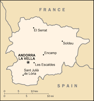
Andorra_map.png (329 × 354 pixels, file size: 6 KB, MIME type: image/png)
Summary
| Description | Andorra map from CIA World Factbook, converted from original GIF format |
| Date | |
| Source | CIA World Factbook |
| Author | United States Central Intelligence Agency |

|
File:Andorra map.svg is a vector version of this file. It should be used in place of this PNG file when not inferior.
File:Andorra map.png → File:Andorra map.svg
For more information, see Help:SVG. |
 |
Licensing
This image is in the public domain because it contains materials that originally came from the United States Central Intelligence Agency's World Factbook.
|
 |
File history
Click on a date/time to view the file as it appeared at that time.
| Date/Time | Thumbnail | Dimensions | User | Comment | |
|---|---|---|---|---|---|
| current | 22:55, 17 Hepetema 2012 | | 329 × 354 (6 KB) | OgreBot | (BOT): Uploading old version of file from en.wikipedia; originally uploaded on 2005-05-23 07:38:15 by Berkut |
| 20:23, 27 Noema 2004 |  | 330 × 355 (12 KB) | Kneiphof | Andorra CIA map |
File usage
The following page uses this file:
Global file usage
The following other wikis use this file:
- Usage on af.wikipedia.org
- Usage on az.wikipedia.org
- Usage on be-tarask.wikipedia.org
- Usage on br.wikipedia.org
- Usage on ca.wikipedia.org
- Usage on ckb.wikipedia.org
- Usage on cy.wikipedia.org
- Usage on de.wikipedia.org
- Usage on dsb.wikipedia.org
- Usage on en.wikipedia.org
- Usage on en.wikisource.org
- Usage on fa.wikipedia.org
- Usage on fi.wikipedia.org
- Usage on gag.wikipedia.org
- Usage on gom.wikipedia.org
- Usage on ia.wikipedia.org
- Usage on id.wikipedia.org
- Usage on ilo.wikipedia.org
- Usage on it.wikipedia.org
- Usage on ja.wikipedia.org
- Usage on kn.wikipedia.org
- Usage on ko.wikipedia.org
- Usage on lfn.wikipedia.org
- Usage on lt.wikipedia.org
- Usage on ml.wikipedia.org
- Usage on ms.wikipedia.org
- Usage on mzn.wikipedia.org
- Usage on nds.wikipedia.org
- Usage on nl.wiktionary.org
- Usage on ro.wikibooks.org
- Usage on sat.wikipedia.org
View more global usage of this file.