
File:Location of Donetsk People's Republic.png

Size of this preview: 800 × 586 pixels. Other resolutions: 320 × 234 pixels | 640 × 469 pixels | 1,024 × 750 pixels | 1,280 × 938 pixels | 1,694 × 1,241 pixels.
Original file (1,694 × 1,241 pixels, file size: 901 KB, MIME type: image/png)

|
This locator map image could be re-created using vector graphics as an SVG file. This has several advantages; see Commons:Media for cleanup for more information. If an SVG form of this image is available, please upload it and afterwards replace this template with
{{vector version available|new image name}}.
It is recommended to name the SVG file “Location of Donetsk People's Republic.svg”—then the template Vector version available (or Vva) does not need the new image name parameter. |
Summary
| Description |
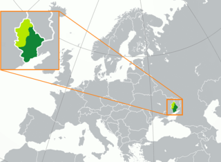
English: territory controlled by the self-proclaimed Donetsk People's Republic (dark green) inside of the Donetsk Oblast (green, light and dark) Русский: Заявленная (светло-зелёный) территория Донецкой Народной Республики, совпадающая с территорией Донецкой области Украины, и контролируемая ДНР территория (тёмно-зелёный) Français : Territoire de la République populaire de Donetsk (vert foncé) dans l'oblast de Donetsk (vert clair) |
| Date | |
| Source |
Own work |
| Author | Oude-rusman |
| Other versions | Derivative works of this file: Location of Donetsk People's Republic (before 2022 invasion).png |
.png)
Licensing
| This map is ineligible for copyright and therefore in the public domain, because it consists entirely of information that is common property and contains no original authorship. For more information, see Commons:Threshold of originality § Maps.
|
File history
Click on a date/time to view the file as it appeared at that time.
| Date/Time | Thumbnail | Dimensions | User | Comment | |
|---|---|---|---|---|---|
| current | 03:31, 23 Pēpuere 2023 | | 1,694 × 1,241 (901 KB) | DinoSoupCanada | Update |
| 19:27, 13 Noema 2022 |  | 1,694 × 1,241 (713 KB) | DinoSoupCanada | Since the article is repurposed as a disputed subject of Russia, then it's fine to edit again. | |
| 22:38, 12 Oketopa 2022 |  | 1,694 × 1,241 (265 KB) | DinoSoupCanada | DPR doesn't exist after September 30th | |
| 19:27, 1 Oketopa 2022 |  | 1,694 × 1,241 (265 KB) | Nahabino | Update per ISW; last update for self-proclaimed DPR state | |
| 23:34, 30 Hepetema 2022 |  | 1,694 × 1,241 (265 KB) | Nahabino | Update per ISW | |
| 22:53, 28 Hepetema 2022 |  | 1,694 × 1,241 (266 KB) | Nahabino | Update per ISW | |
| 23:05, 27 Hepetema 2022 |  | 1,694 × 1,241 (266 KB) | Nahabino | Update per ISW | |
| 23:34, 26 Hepetema 2022 |  | 1,694 × 1,241 (266 KB) | Nahabino | Update per ISW | |
| 09:21, 26 Hepetema 2022 |  | 1,694 × 1,241 (714 KB) | Durranistan | update per File:Russian Occupation of Donetsk Oblast.svg | |
| 08:42, 24 Hepetema 2022 |  | 1,694 × 1,241 (266 KB) | Nahabino | Update per ISW |
File usage
The following page uses this file:
Global file usage
The following other wikis use this file:
- Usage on af.wikipedia.org
- Usage on azb.wikipedia.org
- Usage on be-tarask.wikipedia.org
- Usage on be.wikipedia.org
- Usage on bg.wikipedia.org
- Usage on br.wikipedia.org
- Usage on ckb.wikipedia.org
- Usage on crh.wikipedia.org
- Usage on cs.wikipedia.org
- Usage on cv.wikipedia.org
- Usage on en.wikipedia.org
- Usage on es.wikipedia.org
- Usage on ext.wikipedia.org
- Usage on fa.wikipedia.org
- Usage on fi.wikipedia.org
- Usage on fr.wikipedia.org
- Usage on he.wikipedia.org
- Usage on hu.wikipedia.org
- Usage on id.wikipedia.org
- Usage on ie.wikipedia.org
- Usage on is.wikipedia.org
- Usage on it.wikipedia.org
- Usage on ja.wikipedia.org
- Usage on ka.wikipedia.org
- Usage on ko.wikipedia.org
- Usage on ku.wikipedia.org
- Usage on kv.wikipedia.org
- Usage on lij.wikipedia.org
- Usage on li.wikipedia.org
- Usage on lt.wikipedia.org
- Usage on lv.wikipedia.org
- Usage on ml.wikipedia.org
- Usage on nl.wikipedia.org
- Usage on no.wikipedia.org
- Usage on pl.wikipedia.org
- Usage on pnb.wikipedia.org
- Usage on ps.wikipedia.org
- Usage on pt.wikipedia.org
- Usage on sah.wikipedia.org
- Usage on scn.wikipedia.org
- Usage on sco.wikipedia.org
- Usage on simple.wikipedia.org
- Usage on sl.wikipedia.org
- Usage on sq.wikipedia.org
- Usage on sr.wikipedia.org
View more global usage of this file.