
File:Luxembourg-CIA WFB Map.png
No higher resolution available.
Luxembourg-CIA_WFB_Map.png (326 × 350 pixels, file size: 8 KB, MIME type: image/png)

|
This locator map image could be re-created using vector graphics as an SVG file. This has several advantages; see Commons:Media for cleanup for more information. If an SVG form of this image is available, please upload it and afterwards replace this template with
{{vector version available|new image name}}.
It is recommended to name the SVG file “Luxembourg-CIA WFB Map.svg”—then the template Vector version available (or Vva) does not need the new image name parameter. |
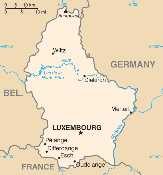
| Description | CIA World Factbook map of Luxembourg | |||||
| Date | ||||||
| Source | https://cia.gov/cia/publications/factbook/maps/lu-map.gif | |||||
| Author | CIA | |||||
| Permission (Reusing this file) |
|
|||||
| Other versions | Derivative works of this file: Luxembourg-CIA WFB Map-sv.png |

File history
Click on a date/time to view the file as it appeared at that time.
| Date/Time | Thumbnail | Dimensions | User | Comment | |
|---|---|---|---|---|---|
| current | 22:56, 17 Hune 2013 | | 326 × 350 (8 KB) | Ras67 | cropped |
| 16:29, 4 Mei 2007 |  | 328 × 351 (8 KB) | Tene~commonswiki | Optimised (0) | |
| 08:51, 30 Hānuere 2006 |  | 328 × 351 (9 KB) | Hoshie | Updated map of Luxembourg from the CIA World Factbook, 10 Jan 06, rev: http://www.cia.gov/cia/publications/factbook/maps/lu-map.gif | |
| 09:15, 27 Māehe 2005 |  | 330 × 354 (7 KB) | Wolfman~commonswiki | {{CIA-map}} |
File usage
The following page uses this file:
Global file usage
The following other wikis use this file:
- Usage on af.wikipedia.org
- Usage on ar.wikipedia.org
- Usage on be-tarask.wikipedia.org
- Usage on bg.wikipedia.org
- Usage on bn.wikipedia.org
- Usage on cs.wikipedia.org
- Usage on el.wikipedia.org
- Usage on en.wikipedia.org
- Usage on en.wikisource.org
- Usage on es.wikipedia.org
- Usage on fa.wikipedia.org
- Usage on fr.wikipedia.org
- Usage on gag.wikipedia.org
- Usage on gd.wikipedia.org
- Usage on gom.wikipedia.org
- Usage on hr.wiktionary.org
- Usage on id.wikipedia.org
- Usage on io.wikipedia.org
- Usage on it.wikipedia.org
- Usage on ku.wikipedia.org
- Usage on lt.wiktionary.org
- Usage on mr.wikipedia.org
- Usage on nap.wikipedia.org
- Usage on nn.wikipedia.org
- Usage on ps.wikipedia.org
- Usage on ro.wikipedia.org
- Usage on ru.wikipedia.org
- Usage on sd.wikipedia.org
- Usage on sl.wikipedia.org
- Usage on sv.wikipedia.org
- Usage on sw.wikipedia.org
- Usage on te.wikipedia.org
- Usage on tr.wikipedia.org
- Usage on tr.wiktionary.org
- Usage on uk.wikipedia.org
- Usage on vi.wikipedia.org
View more global usage of this file.