
File:Wolin-Topomap.png
Original file (1,088 × 784 pixels, file size: 439 KB, MIME type: image/png)
Summary
| Description |
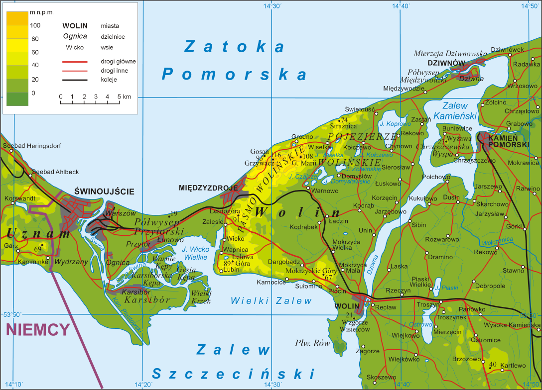
Polski: Mapa topograficzna wyspy Wolin
English: Map of Wolin island, województwo zachodniopomorskie (West Pomeranian Voivodship), Poland. |
| Date | |
| Source | Own work |
| Author | Aotearoa |
Key
in legend:
miasta - towns
dzielnice - town's districts
wsie - villages
drogi główne - main roads
drogi inne - other roads
koleje - railways
Heights in metres
Geographic names:
Zatoka Pomorska - Bay of Pomerania
Zalew Szczeciński - Lagoon of Szczecin
Uznam - Usedom
Niemcy - Germany
Licensing

|
Permission is granted to copy, distribute and/or modify this document under the terms of the GNU Free Documentation License, Version 1.2 or any later version published by the Free Software Foundation; with no Invariant Sections, no Front-Cover Texts, and no Back-Cover Texts. A copy of the license is included in the section entitled GNU Free Documentation License. |
| This file is licensed under the Creative Commons Attribution-Share Alike 3.0 Unported license. | ||
| ||
| This licensing tag was added to this file as part of the GFDL licensing update. |
|
File history
Click on a date/time to view the file as it appeared at that time.
| Date/Time | Thumbnail | Dimensions | User | Comment | |
|---|---|---|---|---|---|
| current | 21:03, 27 Āperira 2009 | | 1,088 × 784 (439 KB) | Aotearoa | Dodanie miejscowości |
| 12:35, 26 Hune 2008 |  | 1,088 × 784 (186 KB) | Aotearoa | {{Information |Description= |Source= |Date= |Author= |Permission= |other_versions= }} | |
| 19:11, 19 Hune 2006 |  | 1,088 × 784 (749 KB) | Aotearoa | Map of Wolin island, województwo zachodniopomorskie (West Pomeranian Voivodship), Poland. Created by pl:User:Aotearoa |
File usage
The following page uses this file:
Global file usage
The following other wikis use this file:
- Usage on az.wikipedia.org
- Usage on be.wikipedia.org
- Usage on bg.wikipedia.org
- Usage on br.wikipedia.org
- Usage on ceb.wikipedia.org
- Usage on ce.wikipedia.org
- Usage on cs.wikipedia.org
- Usage on de.wikipedia.org
- Usage on dsb.wikipedia.org
- Usage on en.wikipedia.org
- Usage on es.wikipedia.org
- Usage on fr.wikipedia.org
- Usage on hu.wikipedia.org
- Usage on it.wikipedia.org
- Usage on kk.wikipedia.org
- Usage on ko.wikipedia.org
- Usage on lt.wikipedia.org
- Usage on mk.wikipedia.org
View more global usage of this file.