Kenetāki
Appearance
| |||||||||||
| Reo | Ingarihi | ||||||||||
| Tāone matua | Frankfort | ||||||||||
| Tāone nui | Louisville | ||||||||||
| Rahi | te 37 | ||||||||||
| - Katoa | 40,444 sq mi (104,749 km²) | ||||||||||
| - Whānui | 140 mi (225 km) | ||||||||||
| - Whāroa | 379 mi (610 km) | ||||||||||
| - % wai | 1.7 | ||||||||||
| - Ahopae | 36°30'N ki 39°9'N | ||||||||||
| - Ahopou | 81°58'W ki 89°34'W | ||||||||||
| Taupori | te 26 | ||||||||||
| - Katoa (2000) | 4,173,405 | ||||||||||
| - Kiato | 101.7/sq mi 39.28/km² (te 23) | ||||||||||
| Teitei | |||||||||||
| - Wāhi teitei | Black Mountain 4,145 ft (1,263 m) | ||||||||||
| - Teitei toharite | 755 ft (230 m) | ||||||||||
| - Wāhi pāpaku | Mississippi (awa)[1] 257 ft (78 m) | ||||||||||
| Whakaurunga | 1 Pipiri 1792 (te 15) | ||||||||||
| Kāwana | Steve Beshear (D) | ||||||||||
| Mema kāhui hanga ture | Mitch McConnell (R) Jim Bunning (R) | ||||||||||
| Wāhi taima | |||||||||||
| - eastern half | Eastern: UTC-5/DST-4 | ||||||||||
| - western half | Central: UTC-6/DST-5 | ||||||||||
| Tohu karere | KY US-KY | ||||||||||
| Paetukutuku | www.kentucky.gov | ||||||||||
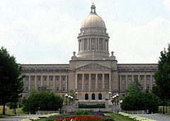
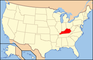
Ko Kenetāki (reo Pākehā: Kentucky) he wāhanga whenua o te Hononga-o-Amerika. Ko Frankfort te tāone matua; ko Louisville te tāone nui.

Ko ngā wāhanga whenua e pātata ana ko Werinia-ki-te-uru me Werinia ki te rāwhiti; ko Tenere ki te tonga; ko Merore ki te uru; ko Irinoi, ko Īniana, me Oheio ki te raki. Ko te rohe ki te taha raki o Kenetāki ko te Awa Ohio, ko te rohe ki te uru ko te Awa Mihihipi. I whānau mai a Aperehama Ringikana rāua ko Jefferson Davis i Kenetāki.
| Taupori o mua | ||
|---|---|---|
| Kautenui | Taupori | %± |
| 1790 | 73,677 | - |
| 1800 | 220,955 | 199.9% |
| 1810 | 406,511 | 84.0% |
| 1820 | 564,317 | 38.8% |
| 1830 | 687,917 | 21.9% |
| 1840 | 779,828 | 13.4% |
| 1850 | 982,405 | 26.0% |
| 1860 | 1,155,684 | 17.6% |
| 1870 | 1,321,011 | 14.3% |
| 1880 | 1,648,690 | 24.8% |
| 1890 | 1,858,635 | 12.7% |
| 1900 | 2,147,174 | 15.5% |
| 1910 | 2,289,905 | 6.6% |
| 1920 | 2,416,630 | 5.5% |
| 1930 | 2,614,589 | 8.2% |
| 1940 | 2,845,627 | 8.8% |
| 1950 | 2,944,806 | 3.5% |
| 1960 | 3,038,156 | 3.2% |
| 1970 | 3,218,706 | 5.9% |
| 1980 | 3,660,777 | 13.7% |
| 1990 | 3,685,296 | 0.7% |
| 2000 | 4,041,769 | 9.7% |
| Wāhanga tōrangapū o Te Hononga-o-Amerika | |||||||||
|---|---|---|---|---|---|---|---|---|---|
| |||||||||
- ↑ Cite error: Invalid
<ref>tag; no text was provided for refs namedusgs


